Tuesday, August 24, 2010

Quandary Peak


This past Monday I had an opportunity to knock another Colorado 14er off my list and getting me one step closer to completing the Mosquito Range. My friend and yoga instructor, Christen, has done several 14ers in past years and was up for conquering another one. Seeing as how motivated I am she wanted to hike one with me so we picked a date and a peak. Quandary was a natural choice because not only is it an easy class 1 hike (class 2 towards the summit) but it's also close to Breckinridge. Christen's in-laws just so happen to have a condo up in Silverthorne which she graciously offered for us to spend Sunday night. This meant we wouldn't have to get up nearly as early as we would had we come straight from Denver and also gave us a chance to get to know one another better.

Our planned time to hit the trail was 6:30am but by the time we got up, loaded the car up and got coffee and found the trailhead it was more like 7:15. The trail head is a little hard to find because there are signs off highway 9 south for Quandary with an arrow pointing right but the parking area here is not the right one. Our directions from 14ers.com said to turn off on to Blue Lakes 850 road. While there was a small parking area and what looked like a trail where the road sign pointed to Quandary, I didn't see a national forest trail head sign nor did I see any cars. Any 14er, even on a Monday, has cars in the lot. So we drove a few more miles down highway 9 until we saw the actual small sign for Blue Lakes 850 and then turned right off of that onto McCullough Gulch 851 road. The trail starts on the left side of the road, and apparently this one replaces an older trail head which starts further up the dirt road.

There were dark clouds in the area and a few sprinkles of rain but no thunder so we headed up the trail. In my experience, if there is no thunder you are pretty safe to assume the weather might burn off if it's morning. I have been wearing North face pants that are waterproof instead of my usual yoga pants and this morning it paid off as we hiked through quite a bit of light rain. I also wore my light down jacket that is water resistant and carried an emergency rain pancho in case the weather worsened.

The first mile or so was a very nice dirt trail that wound through evergreens and aspens. The dogs loved running through the woods and the trees kept most of the early morning rain off us. It gradually got steeper until we reached a clearing and then the rock stairs started. For the remaining 2 or so miles until the summit it was all rocks and exposure although the rocks were big making them easier to hike on than the small scree rocks that made up Mt. Yale. From the route directions we knew we would reach a false summit at the ridge which was about 13,150 feet and then the real summit would be visible. It was slow going because of the rain and wet slippery rocks and the clouds were moving in around the top. Christen and I agreed if anyone heading down were to tell us conditions were bad up there we would turn around. Everyone we saw, however, that were heading down said that it was cold, windy and socked in with clouds at the top but other than that everything was fine. No snow or lightening? We were good to go!


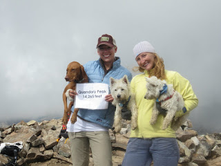
While the wind did pick up a little closer to the summit, it never reached the level that Evans was last week making it a very manageable climb. We finally reached the summit at about 10:15 just as the clouds were starting to open up and blue sky was revealed. There were only 2 other people sharing the summit with us at this point and it is a fairly spread out summit which made it nice for us to enjoy the views as they came. The clouds kept moving in and out so you had to take advantage taking pictures as the opportunity presented itself.


As with any summit, after a light snack, the cold began to wear at our fingers and it was time to start making our way down the mountain. While your legs and feet are infinitively more tired at this point, going down is always the best part of the hike. The weather began to clear even more giving us amazing views of the Hoosier Dam and Breckinridge and after a mile or so it became warm enough for us to shed our jackets and enjoy the sun. Now that we could actually breathe again, Christen and I were able to carry on great conversations about everything from yoga to skydiving. I was grateful to have this opportunity to get to know her outside of class and enjoyed having a hiking partner that was my equal. She kept me motivated the entire hike and we were able to finish the entire loop in about 5 hours. This is a mountain I could have easily climbed alone but I relish any hiking partners I can find! So many people are flaky with their intentions in this day and age and I'm glad Christen committed from the beginning and saw our goal through to completion.


Mt. Quandary was my 9th mountain to complete this summer, brining me one step closer to my goal of 54. It was something I had been looking forward too and rounded out my weekend very nicely. If I could hike every Monday I wouldn't dread them nearly as much! Of course the beginning of my weekend was filled with a trip to Birmingham....but that's another blog story....
Tuesday, August 17, 2010

Consequences

As I posted a few blogs ago there are a few of Colorado's 14er mountains that I doubted I could ever climb due to the sheer technical skill involved and the consequences in hiking them. This past Sunday on the news there was another story about a 20 year old hiker that died on the Maroon Bells. (read the full story here: http://www.cubuffs.com/ViewArticle.dbml?DB_OEM_ID=600&ATCLID=204977528) It's an all too real reminder just how much these mountains should be feared and respected.

Of course, this man, Spencer Nelson by all accounts did everything right. He was hiking with 7 people including his father and on the traverse from South Maroon Peak which he had already summitted to the other he was hit in the head by a rock and, even though he was wearing a helmet was knocked 600 feet into the Bell Cord.


This picture above gives you an idea of the South Maroon Peak and where the bell cord sits


Here's a picture of the Bell Cord in winter conditions. The Bell Cord is climbed with snow in it traditionally and very early in the morning before the sun has a chance to hit it and make it slushy and impassible. I'm not sure of the slope but the degree of steepness here probably about 45. A fall down here as you can imagine, would be deadly especially in the summer when it's just an open field of rocks.

Nelson's goal was to hike all of Colorado's 14ers as well and he was in shape and a good mountaineer. Way more equipped and prepared than I am at this stage to hike anything like this. Yet it just goes to show how unforgiving this mountain can be and how the consequence in pursuing a dream ended in death. They don't call them the Deadly Bells for nothing.


They are beautiful though.


A look at the traverse you would face from one Maroon Peak to the other. Not for the faint of heart.

Nelson is the third hiker I've heard of who has died this summer on a Colorado 14er. The other was Kevin Hayne, an 18-year old who fell off Little Bear Peak (full story here: http://www.krdo.com/news/23915181/detail.html) He was hiking with a friend when they got stuck in the notorious Hourglass and found they could not pass it due to ice. While trying to decide what to do Hayne lost his hand hold and fell. He was alive when his climbing partner found him but died before rescue helicopters could reach him. As I've posted before, Little Bear is another "Everest" on my list of scary mountains that I don't know if I would ever climb. Pictures I'm sure don't even do it justice:


Looking up the hourglass


You can see where the Hourglass gets its name from in the photo above.

And on July 17, 29-year-old Jeffrey R. Rosinski of Rhode Island was found dead at around 3 am on Longs Peak (full story here: http://www.denverpost.com/news/ci_15536716) The 22-year-old that found him said the winds on the summit that evening were so strong that he had to crawl on his hands and knees. On the way down he found a backpack on the trail and then saw blood and when he looked over the ledge he saw Rosinski. I'm guessing Rosinski was blown off the mountain due to the high winds. Longs Peak is considered a difficult 14er but most people don't have a problem until after they reach this:
The keyhole


The Hike itself is 14 miles round trip making it one you have to start very early (like midnight we are talking here) just to be able to summit and make it down before any weather moves in. The problem with the trail after the keyhole is that it is the real exposure begins starting with the Narrows. As you can see from the photos below from the route map listed on 14ers.com there is no room for error and that even in the best conditions you are playing with fate here:


After the Narrows you must climb up the appropriately named "Homestretch" to reach the summit:


Little Bear and the Maroon Bells aren't even in the same category of difficulty as Longs Peak so you can imagine how much harder they are. The fact of the matter is that the rock is more stable on Longs making this climb up a bit easier for the experienced climber.

I truly believe when it's your time to go it's your time to go and that every day we are alive is a gift given to us. You could die driving to work, in a plane crash, your house could catch on fire or you could fall off the sidewalk into traffic. However, I believe in minimizing risk in being prepared for what life has to offer. If hiking 14ers is going to be my new hobby, and it is, you have to take the good the bad and the ugly with them. That means knowing that people die and hikers get hurt even on something as simple as Mount Bierstadt (a climber had to be rescued sunday after a boulder rolled over his leg giving him a compound fracture. This is the same mountain I climbed solo last week!). So while I may be scaring myself, and some of you out there reading this, I just want to maintain awareness. This winter I plan on doing some indoor rock climbing as well as getting rock climbing belay certified just so that when it comes time to hike these harder routes, I will be prepared. Of course, the mountain will always be waiting and ready for me...the question is, when am I ready for it?

Friday, August 13, 2010

And they say it couldn't be done


(picture: Mt. Evans as seen from Echo Lake)


Today marked my goal completion of hiking 8 14ers for the summer with my hike of Mt. Evans. When I set this New Year's resolution I couldn't have dreamed I would have finished out what I started to do and I definitely owe my friends and husband who have provided me with excellent hiking buddies. Today, however, I hiked solo because everyone is slaving away at work while I'm playing. It's a tough life. With 5 more 14ers lined up to round out the summer I am exceeding my own expectations and I couldn't be happier about that.

Mt. Evans was a mountain I was dreading but picked to hike solo simply because it's such a big tourist spot that I knew I wouldn't be completely alone. There are ten routes which Evans can be approached including the Bierstandt, Sawtooth combination, with the standard route being the West Ridge via Chicago Creek. I choose the Northeast Face from Summit Lake because it's only 3 miles round trip instead of 16. After hiking Yale which was 10 I know mentally I would not want to hike 16 miles solo. Perhaps someone will want to hike this with me next year because I'd love to take that route eventually.


(picture: view from Summit Lake)
I dreaded Mt. Evans because there's a road that leads all the way to the top of the mountain and save for a few switch backs, you arrive at the summit without ever having to leave your car. Although it's great for everyone to be able to make it to the top of a 14er and enjoy the views, the road leading in is a little intrusive and cheapens the feel of the mountain. However, based on my drive in, it seems the most popular route up the mountain is biking. You have to drive very slowly through the switch backs because there are bikers around every corner and even some (insane) joggers. If you take the standard route on the Chicago Creek you do not have to pay the $10 fee to enter the wilderness area because the trail head starts before the fee area. To get to Summit Lake you take exit 240 at Idaho Springs of I-70 then drive south on Colorado 103 until the pay area (about 13.5 miles) then it's 9 miles from there to the Summit Lake area. I was told that this trail was closed but that if anyone asked to say I simply wanted to hike to the top and I wouldn't have a problem.

Of course finding the trail was the hard part as there isn't a trail head as you can see from these photos below which I relied on from the 14ers.com website:


I did see some people hiking up the road but I would definitely wager this is a more direct route.

Because it was a 3 mile hike I didn't come prepared like I normally would, leaving my gloves and fleece layer at home. I figured it was only three miles and every time I bring my extra layer I never wear it because I get so hot hiking. Well that was a big mistake today. When I checked in at the fee station the guy told me that it had been 20 degrees at the top the other day and that it snowed up there last night. He said, "I hope you stay warm!" Possibly I did not look prepared. Driving up to the Summit Lake I could see the Aspen trees bending in the wind and feel the push on my car. This was not a good sign. When I opened the car door at the parking lot the wind nearly ripped it from my hand. The wind was bad, so bad at times that I got almost knocked from my feet. The sun was shining but it was cold and without gloves or an extra layer or even a hat to shield my ears or something to pull over my face...well let's just stay I suffered for this mountain. I think my hands are still swollen. Lesson learned, better to bring things you don't need than need things you don't bring.

At the top before you reach the actual summit are several look out binoculars and the partially-rebuilt remains of the Crest House which once contained a restaurant and a gift shop. It burned down on Sept. 1 1979.


You can see great views of Pikes Peak among other mountains as well as the Summit Lake below. The switch backs from the parking lot up are easy to follow and I'd highly recommend this peak for anyone wanting to bring an out of town guest who wants to stand on a 14er but can't make the hike. As you can imagine, at the top elevation of 14,265 feet it was even more cold and windy than where I started. Bebe and I didn't stay long before retreating and running into some mountain goats on the way down. This was the first time I had actually seen wildlife when hiking one of these mountains so I was pleasantly surprised.


(picture: bebe and I made it to the top!)


Mount Evans really was a beautiful mountain and for being such an iconic peak (it dominates the Denver Metro Area Skyline) I'm glad I was able to call this my goal satisfying number 8. I do, however, look forward to tackling the San Juan Mountains over Labor Day. Once I complete Longs and Pikes Peak I will be done with the Front Range mountains...another accomplishment to look forward to in the future!

Thursday, August 12, 2010

A Healthy Fear

When I decided to undertake my journey of accomplishing climbing all of Colorado's 54 14ers, I knew in the back of my mind there would be some I may never be able to climb. The majority of the mountains are ranked in the moderate to easy range which means a lot of class one and two and a little class three hiking. The rankings are based on the terrain and difficulty of the climb. 10 of the mountains are rated in the difficult category including Crestone, Longs, Kit Carson, El Diente, Maroon Peak, Snowmass Mtn., Mt. Eolus, Mt. Lindsey, Wilson Peak and Wetterhorn Peak. None of these really scare me except Maroon peak probably because in my mind there are 7 others to be much more terrified of, these include Mt. Wilson, Crestone Needle, Capitol Peak, Sunlight Peak, Little Bear Peak, Pyramid Peak and North Maroon Peak. These are rated most difficult and all involve at least some class 4 if not class 5 climbing. A few involve ropes and harness and all involve helmets. People die climbing these every year. Die. On a hike.

Here's a look at what you would have to climb on Pyramid Peak:


You can see where it gets it's name from. It's only 14,018 feet and the 47th highest in the state but it's very steep. What also makes this mtn. difficult is the routes to the top are confusing and hard to find with high exposure and a great deal of loose rock. The standard routes to the top are two of the most difficult and dangerous standard routes on the Colorado 14ers. As you can see from this picture if any weather hit you would be stuck on one of these narrow ledges exposed to the elements leaving you vulnerable. Not a good place for a climber to be when a lightening storm moves in!

The Maroon Bells, or the "deadly bells" are some of the most beautiful and feared mountains in the state of Colorado.


There's actually a sign at the trailhead warning hikers of "downsloping, loose, rotten and unstable" rock that "kills without warning." Unlike other mountains in the Rockies that are composed of granite and limestone, the Bells are composed of metamorphic sedimentary mudstone that has hardened to rock over millions of years. This gives the Bells their distinct maroon color. Mudstone fractures easily which makes for a dangerous climb.
This picture shows the route one would have to take to the summit. As you can see it's long arduous. I have heard the rock up here compared to climbing on a bunch of china dinner plates. Probably not for me although they are gorgeous to photograph.


Capitol Peak takes second place for scaring me the most. It's also one of the most difficult 14ers in Colorado to climb. There's only one non-technical route which involves crossing the famously exposed "Knife Edge." Of course many fatalities have occurred on this route and the other routes involve technical rock climbing which have their own perils due to loose rock (although the rock is not said to be as loose as that of the Maroon Bells or Pyramid Peak).
Here's a photo of a climber going over the knife edge on the way to the summit.


Another picture to give you just an idea of the
scale of this mountain


And if this view of the knife edge doesn't scare you than nothing will....


While Capitol Peak does scare me, it's number two on my list because I still think it's "do-able." There's a company called Aspen Expeditions (aspenexpeditions.com) which you can sign up to have a guide that will take you to the summit. I'm not above hiring someone more experienced than me to guide me up a mountain once I get more climbing experience. Plus I think a guided trip would be another way to see and learn more about mountaineering.

Little Bear Peak in the Sangre de Cristo mountain range is about as awful as it gets when it comes to 14ers. It's an exposed class 4 scramble hike and is composed of pre-Cambrian granite estimated to be approximately 1.8 billion years old. An 18 year old respected climber from Highlands Ranch, Colorado just died recently when he lost his hand grip in the Hourglass section of the hike.
Oh the Hourglass:


This picture is looking up the top of the Hourglass which is an almost verticle stretch of water-polished granite famous for the amount of rockfall that comes down the middle earning it the nickname, "The Bowling Alley." If anyone is climbing above you they can easily kick down some loose rock which could hit a climber below and knock them off the mountain. The water that drains down not only makes the rock slippery but ices easily making this 300 foot section a mess.
If you even make it to the top of this mountain, and few climbers have, you can try your luck at the connecting ridge to Blanca Peak which is one of the most challenging outings of its type in the state. Once you commit to this traverse there is no going back.


This picture above shows the connecting ridge from Little Bear to Blanca.


A picture of Little Bear from the Lake Commo area.

So these are my worst fears in the world of 14er hiking. I am hoping though, that as I hike more and become more confident they won't scare me as much. Right now they are all I can think about. The more stories I read, the more I scare myself and yet the more intrigued I am. I read somewhere that if your goals in life are completed in your lifetime, than you aren't dreaming big enough. This is a goal that I might never accomplish but I realize I am OK with this as long as I come as close as I physically can. Of course I don't want to die on a mountain but then again you can die driving your car on the way to work so you can't be scared to live your life.

I have my sites set on Evans, Quandary, Sherman, Redcloud, Handies and Sunshine peak in the future. I will exceed my goal of hiking 8 for the summer by 5 if this all pans out the way I hope it will. I actually flew with a flight attendant at the beginning of summer and when I told her my goal of hiking 8 14ers she looked me dead in the eye and said, "Well I doubt you'll make it, you'll probably only get 3-5 in at the most" Which just goes to show, never judge someone you don't know very well!

Sunday, August 8, 2010

Mount Bierstadt and Mount Yale


At the beginning of this summer I set a goal of hiking 8 of Colorado's 14ers. Since June I have hiked 4, and with summer coming to a close I knew in my heart I would really need to step it up if I wanted to reach my goal. I decided that reaching that goal might mean that I would be on a solitary journey and if it came to that so be it. I have every Thursday through Sunday off at work this month so that would give me plenty of days to try and fit in as much hiking as possible. My friend Meghan had emailed me after the Kite Lake camping trip and said her and her husband Neil were attempting Mount Yale the next weekend so I told them to count me in. Knowing I had a free day off during the week however, I started researching which of the 14ers I could hike alone safely so I decided to attempt Mount Bierstadt on Thursday before camping this weekend.

The trail head for Mount Bierstadt begins at the crest of Guanella Pass (elevation 11,669ft) which is about an hour and a half from Denver. As always I went to my go to guide at 14ers.com to see the best trail route and what to expect etc. It's a good thing I did because I read that Guanella Pass was closed from the highway I-70 Georgetown side due to road construction so I had to take 285 to a small town called Grant and head up the pass from there. I ran into someone on the hike on my way down and he said he was getting such a late start because he didn't know the pass was closed from I-70 which cost him precious hours hiking. This is why you always want to do your homework ahead of time!

At the top of the pass was a parking lot which I assumed was the trail head (and turns out I assumed correct) but there were no immediate signs from the pass or in the parking lot indicating I was in the right place. I arrived about 7:15 and the parking lot had about 10 cars in it with some people in the lot with backpacks on that had just arrived; which indicated to me I was probably in the right spot. I set off for the trail head with my dog bebe and a few feet in saw the Park sign indicating the Bierstandt trail. I knew I would be crossing through the meadows which were full of willows and was warned from various websites it would be marshy. However, there were wooden bridges through this damp area and even though there was a stream crossing, I never got too damp or muddy. Waterproof boots, however, are a must have and I'm so glad I spent the extra money on a pair.

The trial was pretty straightforward and since you can see Bierstandt from the parking lot, I knew I couldn't get lost. From Guanella Pass it is approximately a 3 mile hike, with a climb of 2,391 feet. Even though I was hiking solo there were several other people on the trail which was comforting and I stopped for several breaks along the way. On the rocky upper regions of the mountain the route of the trail is marked by a series of cairns. Since I didn't see anyone in front of me to follow, I followed the cairns to the best of my ability but there were quite a few so I wasn't sure which way was the best to ascend to the top. When in doubt, keep going upwards, which is what I did until I finally summited around 10:30am.


(picture Bierstandt on the right with sawtooth in the middle)


Once at the summit I could have continued along the Sawtooth to reach Mount Evans but weather looked like it was moving in so, along with a father and his two kids who were up there, I began to descend. I actually hiked with this family the whole way down and had a great conversation with them. Hiking alone is quite a mind trip especially when you are summiting a 14er because you have to rely on yourself to keep going and not quit. While I enjoyed the beauty and solitude, I was grateful to have someone to keep me company besides my dog on the way back to my car. The total trip took me about 5 hours.


Mount Yale is also rated as a class 2 14er like Bierstandt but in difficulty it's ranked as moderate. It's one of the 9 14ers in the collegiate peaks and has gained popularity as a non-technical 14er (aka no ropes, helmets or other gear or skill needed) and it's often considered a "training" 14er for those who want to hike more difficult ones. Mount Yale is located in the the Sawatch mountain range which is home to 15 fourteeners and 14 centennial thirteeners; no other Colorado mountain range contains as many peaks above 13,800 ft. When hiking this range, there are a few things you can count on, long approaches, plenty of vertical, and endless class 2 hiking. Mount Yale is the eighth highest peak in the Sawatch Range and twenty-first in the state of Colorado.

Since I needed to drive to Buena Vista (about 2.5 hours away) to conquer this hike I decided to meet my friends Meghan and Neil on Friday night for dinner then camping in the Collegiate Peaks wilderness. We planned to get up at about 5:45am and hit the trail, which was near the campground, by 6 but ended up actually starting at 6:30. What can I say it's hard to get out of your sleeping bag when it's cold outside! We took the standard route which started at the Denny Creek Trailhead. The first three miles of the total 4.5 mile (one way) hike are very straightforward and through the wilderness area. There's lots of Aspens and Evergreen's and the Denny Creek runs through the trail which our dogs loved. This was the first 14er I have hiked where you were in the treeline for that long of a period of time which was a nice change. However, this just meant that we had more elevation to gain (4,000) in the long run.


After the treeline ends you reach a ridge and from here it just ascends straight up towards the top of Yale. Even from the base of the treeline you can't see the summit which can get discouraging if you like to have your goal ahead of you to keep motivated.
(picture: the views are starting to get better and better!)


The remainder of the hike from this point out was all loose rock on the trail which made it hard to hike up.


We had to take several breaks from here on out until we finally made it to the saddle at about 11:30am which was at about 13,800feet high. Only 396 more feet until the top! Unfortunately, we had a decision to make. Another group of people were at the saddle with their dogs and they said it was not safe for dogs to climb to the top. In fact, they had actually started up with their three and ended up having to carry them down. Since Meghan and Neil's dog Marley is a Great Pyrenees and weighs over 150lbs (and there's no way I would want to carry bebe down a bunch of loose rock even though she's only 35) we decided we'd have to leave them at the saddle. Marley wouldn't stay tied up so Neil volunteered to stay and let us summit the rest of the mountain. So off Meghan and I went.
(picture: we have to climb up that to get to the summit?!)


The remainder of the climb up to the summit was even more confusing than Bierstandt had been for me and much steeper. Meghan and I ended up going around one side thinking it would be easier and while she made it up and over a few boulders, I had to traverse back around to the front side where I found some people and followed them up to where she was. There weren't a lot of cairns here so it was easy to get "lost." There was a very steep ridge we had to go up and over with drop offs on each side so we spent a lot of time scooting on our butts and focusing on one hand hold at a time. One wrong step or twist of the ankle could have sent either one of us flying down the mountain so we went slow and took our time. We reached the summit at about noon and were very proud of ourselves for all the hard work we put in.

(picture: the ridge we had to climb over on our way to the top as seen from the summit)


On the way down we didn't want to go back over the ridge so we decided to hike down a little and traverse over to the saddle. This ended up being a bad idea because there was lots of loose rock and although we weren't as high in elevation, there was no set trail so there was a lot of guess work, rocks sliding, butt scooting and even my pants ripping. We made our way to the trail below the saddle where Neil met us with the dogs. Since we had been gone about an hour and the weather was moving in we decided to all make our way down together. Although going down usually takes less time, it was slow going until we got to the treeline because of all the loose gravel. When you've been hiking about 6 hours, your legs start to feel a little shaky and we definitely did not want anyone to fall or twist a knee or ankle. We made it back to the car before the rain at about 3pm.


Mount Yale was the most testing mountain and 14er (my lucky number 7!) I've completed to date. I'm learning a lot about myself on these hikes though and just how capable my body is. Even though I was nervous of the heights summiting both Bierstandt and Yale because of the boulder scrambling I had to do, I focused and was able to reach the top. I read somewhere that when you are scared at the task at hand you simply make your world smaller. Instead of looking at the mountain as a whole you have to break it up into pieces...rewarding yourself for each small marker you reach along the way. I set a goal to hike 8 this summer but have already set Evans, Quandary and Sherman on my horizons and hopefully more to come. What I am most thankful for is having friends like Meghan and Neil who are indulging my new obsession with summiting 14ers. Hiking alone may be fun at times, but it's definitely nice to share your passion with others who have the same goal in mind as you do. I look forward to the many challenges the other 14ers will bring me!