

This past Monday I had an opportunity to knock another Colorado 14er off my list and getting me one step closer to completing the Mosquito Range. My friend and yoga instructor, Christen, has done several 14ers in past years and was up for conquering another one. Seeing as how motivated I am she wanted to hike one with me so we picked a date and a peak. Quandary was a natural choice because not only is it an easy class 1 hike (class 2 towards the summit) but it's also close to Breckinridge. Christen's in-laws just so happen to have a condo up in Silverthorne which she graciously offered for us to spend Sunday night. This meant we wouldn't have to get up nearly as early as we would had we come straight from Denver and also gave us a chance to get to know one another better.
Our planned time to hit the trail was 6:30am but by the time we got up, loaded the car up and got coffee and found the trailhead it was more like 7:15. The trail head is a little hard to find because there are signs off highway 9 south for Quandary with an arrow pointing right but the parking area here is not the right one. Our directions from 14ers.com said to turn off on to Blue Lakes 850 road. While there was a small parking area and what looked like a trail where the road sign pointed to Quandary, I didn't see a national forest trail head sign nor did I see any cars. Any 14er, even on a Monday, has cars in the lot. So we drove a few more miles down highway 9 until we saw the actual small sign for Blue Lakes 850 and then turned right off of that onto McCullough Gulch 851 road. The trail starts on the left side of the road, and apparently this one replaces an older trail head which starts further up the dirt road.

There were dark clouds in the area and a few sprinkles of rain but no thunder so we headed up the trail. In my experience, if there is no thunder you are pretty safe to assume the weather might burn off if it's morning. I have been wearing North face pants that are waterproof instead of my usual yoga pants and this morning it paid off as we hiked through quite a bit of light rain. I also wore my light down jacket that is water resistant and carried an emergency rain pancho in case the weather worsened.
The first mile or so was a very nice dirt trail that wound through evergreens and aspens. The dogs loved running through the woods and the trees kept most of the early morning rain off us. It gradually got steeper until we reached a clearing and then the rock stairs started. For the remaining 2 or so miles until the summit it was all rocks and exposure although the rocks were big making them easier to hike on than the small scree rocks that made up Mt. Yale. From the route directions we knew we would reach a false summit at the ridge which was about 13,150 feet and then the real summit would be visible. It was slow going because of the rain and wet slippery rocks and the clouds were moving in around the top. Christen and I agreed if anyone heading down were to tell us conditions were bad up there we would turn around. Everyone we saw, however, that were heading down said that it was cold, windy and socked in with clouds at the top but other than that everything was fine. No snow or lightening? We were good to go!


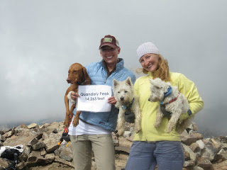
While the wind did pick up a little closer to the summit, it never reached the level that Evans was last week making it a very manageable climb. We finally reached the summit at about 10:15 just as the clouds were starting to open up and blue sky was revealed. There were only 2 other people sharing the summit with us at this point and it is a fairly spread out summit which made it nice for us to enjoy the views as they came. The clouds kept moving in and out so you had to take advantage taking pictures as the opportunity presented itself.


As with any summit, after a light snack, the cold began to wear at our fingers and it was time to start making our way down the mountain. While your legs and feet are infinitively more tired at this point, going down is always the best part of the hike. The weather began to clear even more giving us amazing views of the Hoosier Dam and Breckinridge and after a mile or so it became warm enough for us to shed our jackets and enjoy the sun. Now that we could actually breathe again, Christen and I were able to carry on great conversations about everything from yoga to skydiving. I was grateful to have this opportunity to get to know her outside of class and enjoyed having a hiking partner that was my equal. She kept me motivated the entire hike and we were able to finish the entire loop in about 5 hours. This is a mountain I could have easily climbed alone but I relish any hiking partners I can find! So many people are flaky with their intentions in this day and age and I'm glad Christen committed from the beginning and saw our goal through to completion.


Mt. Quandary was my 9th mountain to complete this summer, brining me one step closer to my goal of 54. It was something I had been looking forward too and rounded out my weekend very nicely. If I could hike every Monday I wouldn't dread them nearly as much! Of course the beginning of my weekend was filled with a trip to Birmingham....but that's another blog story....
No comments:
Post a Comment